Translate

Showing posts with label American River Trails. Show all posts

3/26/24

American River Trails


American River Trails Traveling along the Mississippi and Missouri Rivers to Little Rock Arkansas Memphis Tennessee Kansas City Missouri Alton Illinois Dubuque Iowa and Alexandria Minnesota
Little Rock 
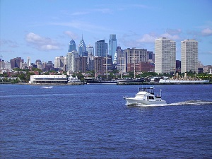
and the Arkansas Inland Maritime Museum Little Rock is a cultural, economic, government, and transportation center within Arkansas and the South located on the south bank of the Arkansas River in Central Arkansas. Fourche Creek and Rock Creek run through the city, and flow into the river.
Little Rock is an Intermodal River Port with a large Industrial Business Complex
Memphis Tennessee and the Mississippi River Museum Memphis is a city with a rich and eclectic history: Home of the Blues, Birthplace of Rock ’n’ Roll, BBQ Pork Capital of the World; it began with the Native Americans who settled on the Fourth Chickasaw Bluff, then onto Hernando De Soto, the Civil War, yellow fever, the blues and rock ‘n’ roll music.
A Display of Fine Art history-making Music and a Celebration of American Heritage and Culture
Mud Island River Park by day, take the monorail, which boasts some of the city’s best views, over to the Mississippi River Museum, where you can check out genuine Civil War garb and gunboat reproductions. By night, catch a live performance at the Amphitheater with the Memphis skyline as your backdrop and the rolling river at your back. The Mississippi River Museum traces the evolution of transportation on the river from the earliest canoes through the golden age of steamboats and modern diesel towboats efficient transportation and the economic impact of river transportation played a vital role in the development of trade routes and the growth of river cities.
Kansas City was founded in the 1830s as a Missouri River port at its confluence with the Kansas River. The City Market, bordering the Missouri River, contains one of the country's largest and longest lasting public farmers' markets in the nation with several unique shops and restaurants.
An Inland Port on the Missouri River KC is the 2nd Largest Rail and 3rd Trucking Hub in America
The Arabia Steamboat Museum is a time capsule of life on the American frontier in the mid-nineteenth century and an opportunity to experience the everyday objects that made life possible for pioneers in the 1800s.  It contains the largest single collection of pre-Civil War artifacts in the world.
The Arabia Steamboat Museum has been a popular Kansas City attraction for over 20 years
Alton Illinois and the National Great Rivers Museum Alton is located 25 Miles north of St. Louis amid the confluence of three navigable rivers, the Mississippi, the Illinois and the Missouri, as a river trading and industrial town. The Great Rivers Region is accessible from six interstates, an international airport and an Amtrak station.
River Trails where Great Rivers Converge with Great Moments in History at the Lewis and Clark Interpretive Center
Grafton’s riverfront was packed with manufacturing companies, mills, quarries, loading docks, and riverboat traffic in the 1800s. Today, it is a tourist destination with its specialty shops and wineries.
Architecture Trails many blocks of housing in Alton were built in the Victorian Queen Anne style during the prosperous period in the river city's history at the top of the hill in the commercial area, several stone churches and city hall.
The National Great Rivers Museum and Melvin Price Locks & Dam feature the importance of the river system to America’s economy from her grand history and cultural significance, to her ecological importance and role as a transportation corridor.
The Mississippi River, over 2,200 miles long, is the second longest river in the United States and the third largest river basin in the world, exceeded in size only by the Amazon and Congo basins. The central portion of the river is known as the Middle Mississippi, a 300-mile reach from Saverton, MO, to Cairo, IL. Further defining the Middle Mississippi are the confluences of three major tributaries, the Illinois, the Missouri and the Ohio Rivers.
The Louisiana Purchase in 1803 marked the opening of the West, and river settlements began to grow. In 1817, the first steamboat arrived in St. Louis and the population soared. Steamboat arrivals had increased more than a thousand-fold by 1858, turning the river into a superhighway.
The Corps of Engineers continually examines the biological impact of the navigational structures on the river’s ecosystem, balancing navigational needs with those of the environment.
The National Mississippi River Museum in Dubuque is located along the Mississippi River at the junction of Iowa, Illinois, and Wisconsin. It serves as the main commercial, industrial, educational, and cultural center for the Tri-State Area. One of the few cities in Iowa with hills, it is also a tourist destination featuring unique architecture and river views.
A Center for Culture with Five Institutions of Higher Learning
Downtown Dubuque is the center of the city's transportation and commercial sectors, and functions as the hub to the various outlying districts and neighborhoods. An area of special note is the Port of Dubuque which has seen a massive amount of new investment and new construction.
Alexandria Minnesota and the Legacy of the Lakes Museum
The Village of Alexandria was settled in 1858. The form of the name alludes to Alexandria, Egypt, a center of learning and civilization. W.E. Hicks was pivotal to the early development of the town. He purchased the townsite in 1868 and established a mill, hotel, newspaper, and store. He donated property for a courthouse, jail, and two churches: Methodist and Congregational.
The Legacy of the Lakes Museum, originally known as the Minnesota Lakes Maritime Museum, promotes lake traditions and legacies as well as preserve Minnesota history.
Minnesota is home to skilled watercraft builders since Native Americans first fashioned birch bark canoes hundreds of years ago. The museum boasts the most complete collection of Minnesota-made boats from Larson to our own Alexandria Boat Works.

3/22/24

The Delaware River Valley


The Delaware rises in two branches and flows 419 miles – 674 Km – into Delaware Bay. Its watershed drains an area of 14,119 square miles - 36,570 km2 - in the five Atlantic Coast States of New York, Pennsylvania, New Jersey, Delaware and Maryland.
Tributaries and Creeks there are 216 tributaries and 14,057 miles of streams and creeks in a watershed that is home to 4 million people and drinking water to 17 million. The Delaware River basin sustains fishing, transportation, power, cooling, recreation, and other industrial and residential purposes. With no dams or impediments on the river's main stem, the Delaware is one of the few remaining large free-flowing rivers in the United States.

The Hudson and the Delaware were originally called the North and South Rivers
History the river was first visited in 1609 by Henry Hudson and the Dutch East India Company resulting in Dutch and Swedish settlements along the lower section of river. The River was renamed Delaware in 1664, after Baron De La Warr, an English nobleman and the Virginia colony's first royal governor. With the removal of the Lenape Indians, the name has been spread to municipalities and counties in the American Midwest and Canada were the tribes resettled.

Development the Delaware River played a key factor in the economic and social development of the Mid-Atlantic region. In the 17th century it provided the conduit for colonial Dutch and Swedish settlement followed by the Quakers in Philadelphia and the Lehigh Valley.

Canals Philadelphia’s importance as a commercial center led to improvements on the upper river; the Pennsylvania Canal running from Easton to Bristol, opened in 1830; the Delaware & Raritan Canal ran on the New Jersey side of the river while the Morris and the Delaware & Hudson Canals provided connections to the Hudson River. The Chesapeake & Delaware Canal linked the Delaware with Chesapeake Bay.


Recreation the Delaware Gap National Recreation Area resulted from the failure of a controversial plan to build a dam to control water levels for flood control and hydroelectric power generation. In 1978, environmental opposition led to a takeover by the National Park Service; surrounding communities developed recreational facilities and worked to preserve the remaining historical structures.
The Lehigh and Delaware River Valley are ideal anchor locations to visit New York City, the Hudson Valley, Philadelphia and South Central Pennsylvania.

The Susquehanna River Valley


The Susquehanna River is 464 miles (747 km) long and is the longest river on the US East Coast. With its watershed, it is the 16th-largest river in the United States, and the longest river in the continental United States without commercial boat traffic today. In the Canal Era, navigation improvements were made to enhance the river for barge shipping of bulk goods by water on the Pennsylvania Canal.
History the river has played an important role throughout American history. In the 18th century, William Penn’s negotiations with the Lenape led to settlements in the lands between the Delaware and Susquehanna rivers and, in late colonial times, anthracite coal was transported. During the American Revolution, an expedition came downriver from its headwaters; the upper portion navigable by damming the river's source at Lake Otsego, allowing the lake's level to rise and then destroying the dam and flooding the river for miles downstream.
Bridges Ferries Canals and Dams prior to the Port Deposit Bridge opening in 1818, the river formed a barrier between the northern and southern states. The earliest dams were constructed to support ferry operations in low water. Its many rapids meant that commercial traffic could only navigate down the river in the high waters of the spring thaws. Two different canal systems were constructed on the lower Susquehanna to bypass the rapids. The Port Deposit Canal was completed in 1802, followed by the larger Susquehanna and Tidewater Canal. Later, bridges replaced ferries, and railroads replaced canals.
200 Bridges and Two Ferries cross the Susquehanna. Canals are preserved as Historic Parks
Harrisburg, the Capital of Pennsylvania, was inhabited by Native Americans as early as 3000 BC. Known as Peixtin, the area was an important trading post for Native American traders, as trails leading from the Delaware to the Ohio Rivers, and from the Potomac to the Upper Susquehanna intersected there.

Hershey is a year-round, world class travel destination with an amusement park, exclusive resorts and family attractions. Surrounded by some of America’s most productive dairy farms, the world’s first modern chocolate factory and model town is a real community.

City Island is a 63-acre tourism and recreational destination containing archaeological treasures of the Susquehannocks and Iroquois tribes which established seasonal settlements here. The island was a stopping off-point for Union soldiers during the Civil War; they crossed over it by way of the Camelback Bridge to defend Harrisburg from the threat of invasion by the Confederate Army. Today, City Island is a tourist and sports venue for the Harrisburg Senators Baseball Stadium, the City Islanders Soccer Stadium, the Pride of the Susquehanna, City Island Railroad, and the City Island Stables.

Millersburg Borough
nestled along the Susquehanna River, is quaint community radiating out from a Victorian Market Square Park featuring a Gazebo dating back to 1891. Millersburg evolved along with the introduction new forms of transportation; travel back to the 17th century and visit the Wiconisco Canal in MYO Park and a restored 1898 passenger rail station on West Center Street. The National Historic Register's Millersburg Ferry System traces its roots to 1817.
Pride of the Susquehanna River Boat is one of the last remaining authentic paddle-wheel riverboats in America. Since her construction and launch in 1988, "The Pride" has carried almost a million passengers who have enjoyed themed cruises and River School Educational Trips.


1/30/20

Hudson River Scenic and Historic Walking Tours


The Hudson Valley extends 150 miles above the tip of Manhattan. Designated as a National Heritage Area, the valley is steeped in history, natural beauty, culture, food and farmers’ markets.

Colonial Era The first Dutch settlement was established at Fort Nassau, a trading post south of modern day Albany, in the early 17th century, with the purpose of exchanging European goods for beaver pelts. The valley also became one of the major regions of conflict during the American Revolution.

19th Century following the building of the Erie Canal, the area became an important industrial center as the canal opened the Hudson Valley and New York to commerce with the Midwest and the Great Lakes.

The natural beauty of the Hudson Valley has earned the Hudson River the nickname "America's Rhineland" a comparison to the famous 40 mile (65 km) stretch of Germany's Rhine River valley.
Navigation the Hudson is navigable for a great distance above mile 0 off Battery Park. The original Erie Canal connected it with Lake Erie enabling shipping between cities on the Great Lakes and Europe via the Atlantic Ocean. The Hudson Valley also proved attractive for railroads, once technology progressed to the point where it was feasible to construct the required bridges over tributaries.


The Erie Canal Cruise or Walk through Historic Villages and Natural Landscapes

Biking, Walking Driving Itineraries and outdoor adventures in the Hudson River Valley includes biking, hiking, horseback riding, golf, kayaking, parasailing, archery and skeet shooting.
Dutchess County is 800 square miles of natural scenic beauty, historic and cultural landmarks, and outdoor recreation. Stroll the Walkway Over the Hudson. Tour and taste along the Dutchess Wine Trail. Explore the homes of FDR and Vanderbilt. Taste new creations at The Culinary Institute of America. Fill the pantry at farm markets. Cruise the Hudson River. 

Hudson River Valley Scenic and Historic Walking Tours

Rockland County is located just 30 miles north of New York City and is known for its quaint villages, spectacular river views and outdoor recreation with 32,000 acres of parklands dotted with sparkling lakes and streams rushing down to the Hudson. Miles marked trails lead right to the foothills of the Ramapo Mountains.
The Village of Piermont formerly Tappan Landing it is is located by a navigable tidal creek linking the Hudson River with Orangetown and the interior. In the 1830s, a pier and a rail link made it the southern terminus connection to Lake Erie. Following the Civil War and the launching of the Nyack and Northern passenger rail line, the Village of Piermont started attracting tourism from nearby New York City.
Upstate New York is home to City and Country Settings and High-tech Industries
Finger Lakes and Watkins Glen State Park is the site of 19 waterfalls and a gorge. Seneca Lake is a long slender lake with wineries along both sides. From Geneva, on the north shore of the lake, you can head east towards Syracuse and visit Destiny USA, sixth largest shopping destination in the United States.

Genesee County Village and Museum is the largest living history museum in the state; a restored 19th century village with historic buildings, craftspeople in authentic dress, a nature center, wildlife gallery and a vintage baseball park.